Sacramento River Monitoring and Assessment Project
The Sacramento River Monitoring and Assessment Project (SRMAP), funded by CALFED in 2007, is a synthesis of three separate 2005 CALFED proposals into one project culminating in a comprehensive approach to monitoring and assessing ecosystem health along the Sacramento River. It represents a diverse project team from researchers from UC Davis, CSU Chico, UC Santa Cruz, and The Nature Conservancy. The Sacramento River Monitoring and Assessment Project comprises five key components: the Sacramento River Riparian Map, vegetation analysis, channel morphology and dynamics analysis, Sacramento River ecosystem scorecard and monitoring plan.
SRCAF assists with public outreach by circulating project documents and workshop notices. The SRMAP project team will regularly give public updates on the project at the SRCAF Board and Technical Advisory Committee meetings and through the SRCAF Project Tracker.
- GIC's Sacramento River Monitoring Data website
This site provides access to aerial photography, vegetation mapping data, and other resources. - Information Center for the Environment (ICE) SRMAP Project page
This website is be used to post reports and other materials associated with DFG/Calfed Ecosystem Restoration Program Grant ERP062002.
 (file size ~ 8 MB)
This report introduces a framework to promote a quantitatively rigorous method of Ecological Integrity Assessment. This framework is designed to provide information needed to evaluate the effects of conservation actions in large landscape-scale projects such as that which TNC and its partners are engaged in on the Sacramento River. When properly applied the framework generates standardized methodologies and testable hypotheses and promotes the advancement and transfer of knowledge among scientists and natural resource managers. Moreover, when appropriately implemented, this methodology should translate to more effective and efficient allocation of scarce conservation resources.
This is the final administrative report for The Sacramento River Monitoring and Assessment Project.
Executive Summary: California's Central Valley once hosted great riparian forests along its many large rivers, in dynamic interaction with their river channels and floodplains. Over a century of wood-cutting, agriculture, water diversion, and urbanization have led to the destruction of >95%of these gallery forests. Over the last decade and a half, the state and private conservation organizations have acquired lands with the purpose of re-planting native vegetation along the Sacramento River in an attempt to restore a portion of the river's historic ecological function. As part of this overall restoration program, restoration and ecological scientists have partnered to determine how best to encourage ecosystem recovery through natural and horticultural means. This science-based monitoring and evaluation plan is one tool that can be used to track riparian vegetation, channel, and floodplain forest riparian condition and recovery in response to natural variation and to various management actions.
A descriptioon of the 2007 Sacramento River Riparian Mapping effort to update the 1999 Sacramento River riparian map. This project was confined to the mainstem of the Sacramento River between Colusa and Red Bluff, an area known as the Ecological Management Zone (EMZ). The EMZ is located between River Mile 144 and RM 245.
- An overview of the Sacramento River Monitoring and Assessment Project (pdf ~3MB)
Author: SRMAP Project Team. A presentation prepared in 2007. - Channel Dynamics Analysis Monitoring (pdf ~3MB)
Author: Eric Larsen. A presentation on meander migration modeling of the Sacramento River. - Vegetation Development in Restoration Sites (pdf ~4MB)
Authors: David Wood and Karen Holl. Are planted restoration sites trending toward high quality riparian forest? Are invasive species a problem? And how do restoration sites compare to naturally established remnant riparian forest? - Natural Vegetation Establishment on Gravel Bars (pdf ~1MB)
Authors: David Wood and Karen Holl. A study on whether native vegetation is establishing on point bars on the Sacramento River. - Long-term Restoration of Riparian Understory Species over Large Spatial Scales (Wood & Holl)(pdf ~3MB)
Authors: David Wood and Karen Holl. A study on native understory species establishment and success.
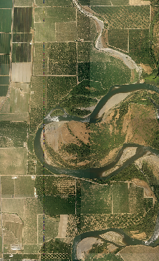
A sample of the 2007 high-resolution aerial photography
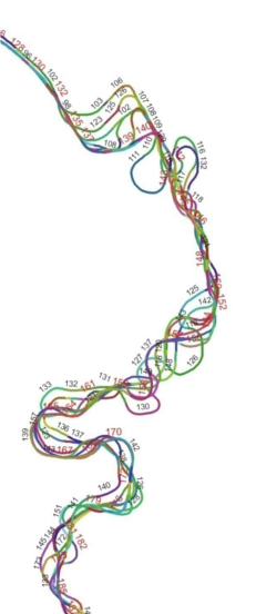
A river meander model image